 The Nile has played a colossal part in history in its mercy mission through the vast deserts of Northern Africa. No other river on earth has played such an important role in the civilization of mankind. The mighty river traverses an incredible variety of landscapes, supports an exotic and diverse range of cultures and wildlife, and flows for thousands of miles without the support of single tributary. Since ancient times, civilizations have tried to explore the Nile; to solve the mystery of it’s sources and to lay claim to life giving powers of the mighty river.
As early as 350 AD, the Greek philosopher Ptolomy mapped with uncanny accuracy the source of the Nile as being a great lake (later named by Speke as Lake Victoria) and what he dubbed ‘The Mountains of the Moon’. Now known as the Rwenzori Mountains, the snows of the Nile are the highest source of the waters at 5109m and Lake Victoria is the largest source – both are found in modern Uganda.
For this reason alone, the colonial powers batted for the territory controlled by the Buganda, Toro and Busogo Kingdoms; for control of the Nile and as a result the western borders of Uganda are drawn along the sources of the great river. On the western side of the DR Congo/Uganda border all the water flows west into the mighty Congo jungle and the river of the same name; east of the border is the watershed of the Nile. Thousands of years earlier, the ancient Egyptians had sent armies upstream in search of the source of the water that supported their civilization for ‘without the Nile; Egypt is nothing’.
Winston Churchill famously referred to Uganda as ‘The Pearl of Africa’ as a result of his 1907 visit and he was merely recognizing what the native Kingdoms had seen hundreds of years before. The creation of the Africa’s great Rift Valleys and in particular the Western Rift made Uganda unique and made the existence of ancient Egypt possible. Without this geographic phenomenon Egypt would have never existed. Large tectonic plates making up the earth’s crust shifted dramatically apart tens of thousands of years ago and prevented the flow of water from the Great Lakes region of Africa to the west. Prior to the creation of the Western Rift massive tropical downpours of the central lakes region swelled mighty rivers merging into the vast tropical jungles of DR Congo and eventually racing into the Atlantic ocean.
The tectonic plate movement in the Western Uganda created one of Africa’s great rift valleys and the only example of it viewable from the air (or Google earth). All other similar formations are hidden beneath thousands of tons of water on the floor of the oceans. The result is a string of mighty lakes with Malawi in the South, Tanganyika further north then in Uganda Lakes Edward, George and Albert.
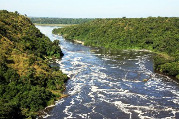
The immense reservoirs of Lakes Victoria and Albert ensure that year-round the mighty flows powerfully North which in itself is a remarkable geographic oddity as few of the world’s rivers head in this direction. The southern end of White Nile between Lakes Victoria and Albert is what we like to refer to as the staircase on of the Nile for it is in this section that the river drops dramatically, explodes in a series of wild rapids and culminates eventually in the creation of Murchison Falls found in the National Park of the same name in Northern Uganda. It is this section of the river that is now home to most heart-pounding whitewater rafting action on the planet.
However, the other astounding geographical fact concerning the Nile is most obvious at Khartoum in Sudan. Where the White and Blue Niles meet, it is the Blue Nile that carries Ethiopia’s largest export. For most of the year, the two distinctly different coloured Niles meander side by side mixing only when out of sight of Khartoum. However, during the wet season in Ethiopia between June and September, the Blue Nile rises in massive flood carrying immense quantities of silt in a tidal wave of floodwater toward Egypt. Wherever the silt was deposited, the farmers had only to wait for the floodwaters to receded a little, plant seeds in the fertile soils, allow his stock to trample them gently into the ground and wait for his crop to grow. Remarkably this tidal wave of silt arrived at the hottest and driest time of the year when any less of a river would have been swallowed by the insatiable Sahara and the burning sun above. The floodwaters of the combined Nile turned vast tracts of hostile desert into rich and valuable agricultural land.
In modern times, however, the creation of the Aswan dam and Lake Nasser on the Egypt/Sudan border mean natures gift of life-giving fertile silt no longer reaches Egypt. The annual floods on which the ancient civilizations of Egypt were built are a thing of the past and the fertile soil is instead trashed on the floor on Lake Nasser. As I write, the construction of another large dam in Northern Sudan at Merowe will drown the 4th Cataract of the mighty river. Beautiful Nubian villages, ancient castles and some stunning desert scenery will be sacrificed in the name of electricity and irrigation. I spent many hours wandering amongst the villages, watching the sunrise over the castles knowing that never again will these views be our privilege to see.
The creation of this dam will mean that Egypt’s most valuable import will not even reach the country. Presently, the heavily laden Nile drops its chocolate brown load on the floor of Lake Nasser and the river runs clear from at the 1st cataract from beneath the Aswan dam. However, in the future, this silt will be captured by Sudan only to rapidly fill the Merowe dam and create another environmental disaster.
As one travels along the Nile in the desert areas, a chorus of motorized pumps leeches water from the Nile to irrigate nearby fields. But of most interest is traditional farming methods still adopted my many of the rural Sudanese. Crops higher up the bank grow tallest as the water receded from these areas first and those recently planted sprout just above the muddy banks.
Source: Adrift Uganda


1 Comment
Rafting the Mighty River Nile | Uganda Tourism Center, 2018-04-20 at 7:29 PM
[…] 20 minutes we got back onto the raft and went through a few other flips in the water. The rapids of the River Nile have interesting names; overtime, Bubugo, Itanda Falls, Vengeance, Hair Of The Dog, Kulu Shaker […]